
By Sophia Schweizer
There is a lot in space we still don’t know much about. Most likely, we’ll still need a bit more time to figure it all out. But perhaps the universe holds the answers to help us save Earth — now. Space technology is playing a crucial role in protecting our planet. But how exactly are satellites contributing to sustainability and what impact is the EU Space Programme having on our environment? In this blog post, we’ll explore the fascinating world of satellite technology and its vital role in the fight against climate change and environmental destruction.
Up in Space
The EU has several methods and programmes to prevent or at least mitigate the consequences of climate change. Beside agreements such as the European Green Deal, the European Union implements the EU Space Programme. This programme pivots on six flagship programmes. Starting with Galileo, which is Europe’s global satellite system focused on sharing data-based information about reliable positioning and timing. This is mostly used by mobile phones and cars. The European Union Governmental Satellite Communications, GOVSATCOM, belongs to the Global Strategy for the European Union’s Foreign and Security Policy and it’s all about cost-efficiency, especially in terms of communications. Another Space Programme is Space Situation Awareness (SSA). Beside operation in the fields of Space Surveillance and Tracking of artificial objects, SSA is also monitoring and forecasting the weather as well as near-Earth objects. A second element of Europe’s Foreign and Security Policy is its youngest space programme: IRISS, Infrastructure for Resilience, Interconnectivity and Security by Satellite. Aiming to make communication systems space-based secure, IRIS should deliver services in 2024 especially in terms of digitalization. To be able to coordinate and navigate these satellite systems the European Geostationary Navigation Overlay Service, EGNOS, was implemented. The service will improve the performance of global navigation satellite systems, such as Galileo. The last programme – and probably the most interesting to us – is Copernicus, which it’s currently considered to be the most ambitious Earth observation programme within the EU. Its main aim is to observe our planet focusing on the environment, in order to be able to provide us with targeted information about climate.
Copern…what?!
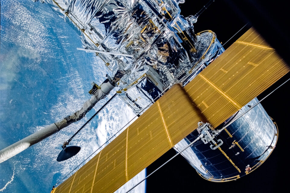
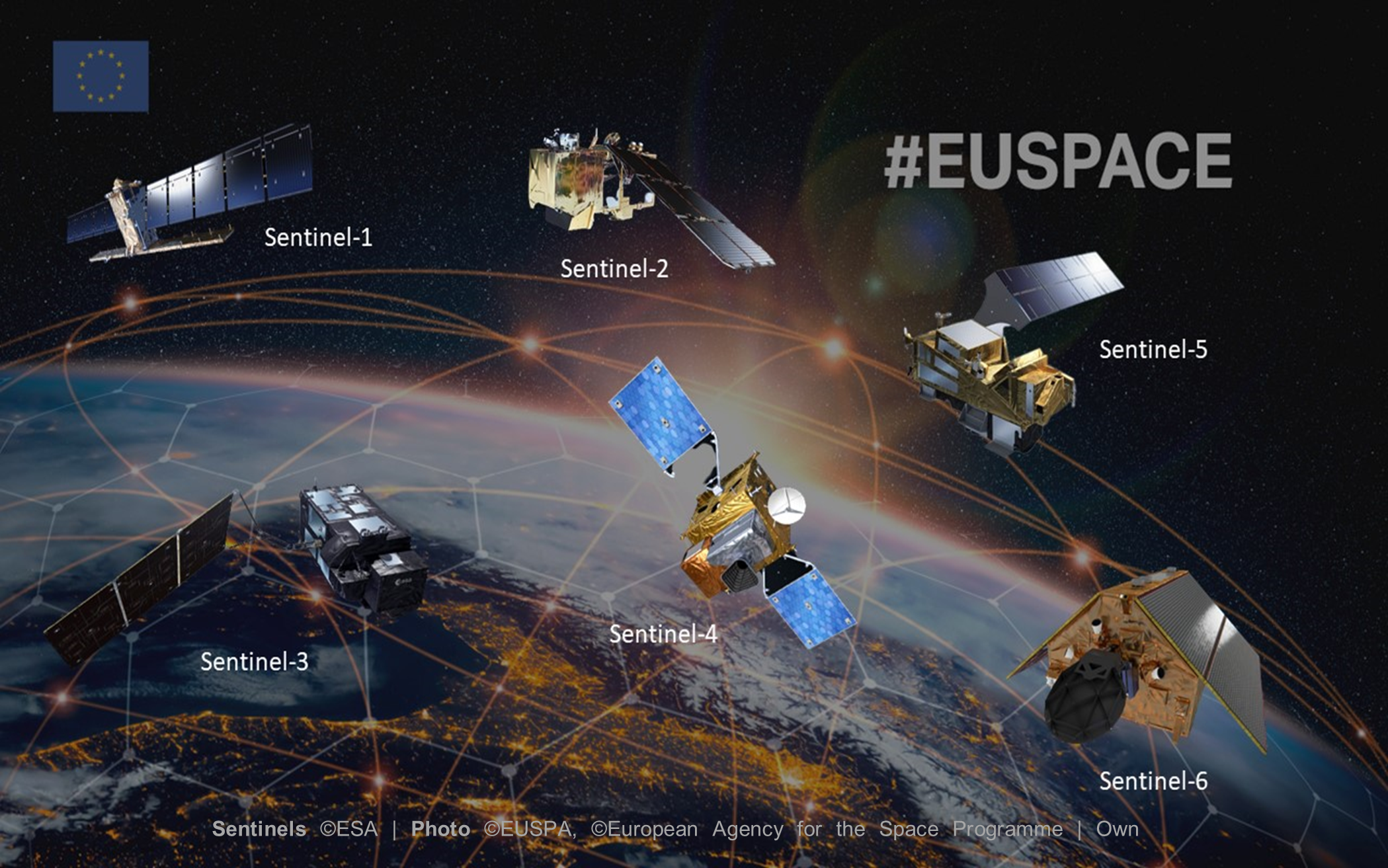
The story behind Copernicus starts a long time ago, in fact 25 years. The idea of a European environment-monitoring programme was born in May 1998. Copernicus was firstly a vision, but is currently the most ambitious and successful Earth-observation programme in the world! Six Copernicus Sentinel satellites are currently in orbit and their main aim is to provide accurate, timely and easily accessible information that can be used to improve the management of environment-related issues. That means that such data can actually help to understand and mitigate the effects of climate change and therefore ensure civil security. So obviously, these satellites are the key element of Copernicus. Each of them has its own measurement instruments to get the best possible coverage of Earth’s surface. Let’s take a closer look at each of them to better understand whether there is any truth in the statement: satellites against climate change.
Sentinel-1 was launched in 2014 and its main purpose is to monitor land and ocean. Especially in terms of glacier flow, oil detection, wind and wave information, as well as ground movements to make predictions about earthquakes and floods. Sentinel-2 (2015) observes the land region and collects data to monitor the agriculture and the aerial extent of fire and therefore provides high-quality pictures. Under the purpose of a European global land and ocean mission, the European Space Agency (ESA), which can be seen as the designer and operator of the Copernicus programme, implemented Sentinel-3 (2016) which records sea level fluctuations, water surface temperature and fire extent. Everything about the quality of the atmosphere is monitored by Sentinel-4 from 2022 and Sentinel-5 (the precursor from 2017 and the current version from 2021). The final one, Sentinel-6 (2020), provides high-precision measurement of the ocean surface topography and delivers data on changes to climate and environment.
Monitoring Mother Nature
So how can this data help us to save our planet? Although we have the data, this information alone doesn’t seem to mitigate climate change. Nonetheless, this knowledge deepens our understanding of the environment: we are indeed able, not only to describe past and present conditions, but also to estimate future ones. Such forecasts can be used by scientists, politicians, advisers and other political actors, as well as from the public and the media to evaluate effects, manage risk, and adopt fruitful strategies. The data is categorised in six fields of application, among them: atmosphere, marine, land, climate change, security, and emergency. Once evaluated, the data gets distributed to the proper sectors which will use it to deal with climate-related challenges, decision making and planning.
Source: AMAP
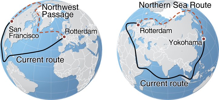
To pick one example, let’s have a closer look at shipping. Shipping is still one of the most important components of the transport network for international trade. The Climate Data Store includes all possible data in relation to past, present, and future development of conditions to be considered in shipping. With this data, routes of vessels can be optimised by calculating their estimated costs.These costs not only include their economic costs but also the environmental ones. Obviously, shipping is one of the biggest polluters and therefore a major contributor to climate change. However,the most iconic route is probably the one towards the Arctic. Whether the availability of the Arctic route can be considered as something “good” probably depends on how we look at it: on the one hand, the route opening is due to the reduction of the Arctic sea ice, which is definitely not an achievement; on the other, the very same reduction of ice implies a decrease in the shipping costs for the companies – to speak in numbers, the route from Europe to Asia passing through the Arctic saves almost 30% of the costs. Less marine fuels use means a decreasing amount of pollutant resulting from engine operation, which ultimately means less pollution. Nevertheless, climate problems will not be solved simply by a shorter shipping route. So this “achievement” brings up a lot of ethical questions about the possibility of using resources that may still pollute the environment, but be less harmful than others.
Is Sky the Limit?
It’s obvious that satellites can’t completely protect us from the effects climate change has on the environment. But they can help us better understand our planet and how to handle these changes. At the moment, there is no better solution than reducing our footprint and being gentler with planet Earth by living more consciously. Nonetheless, the data provided by satellites definitely will have a big impact on the opportunity to find smarter solutions and approaches: in general, in getting greener! Until now we didn’t have the possibility to massively filter UV-rays or to clean the atmosphere from CO2. However, as mentioned before, satellites aren’t the solution. With this regard, the example of the Arctic route shows us how the choice of using the information provided by satellites to enact certain strategies rather than others, it’s the result of an evaluation process that balances pros and cons. It is absolutely necessary that we don’t give up and use everything, even the smallest piece of information we can get, to understand what we can do to prevent things getting worse. Even if that means crossing the Arctic to pollute less than we would using different routes. Since we have to deal with the effects of climate change, it is essential to ask ourselves: how can we turn these effects in our favour to fight against climate change itself? And that is more or less what the satellites can do for us by providing all this information about our oh-so-beautiful world.